Volusia County Shares Latest Forecast and Sandbag Availability Ahead of Heavy Rainfall
Posted On: November 17, 2026
With heavy rainfall expected across Volusia County and the region throughout the coming days, forecasters continue to monitor the potential for localized flooding and further rises along the already elevated St. Johns River. However, considerable uncertainty remains about where the heaviest amounts will fall.
According to the National Weather Service (NWS) in Melbourne, the most likely forecast calls for 3 to 6 inches of rainfall across Volusia County through Saturday, Nov. 21. However, localized amounts of 8 to 12 inches remain possible, particularly along the coast. These higher totals represent less likely, reasonable worst-case scenarios, with a probability of less than 10%.
Even areas that receive lower rainfall totals could experience localized flooding, particularly where the ground remains saturated from earlier this month. While the ground can absorb some additional rainfall, heavy downpours over a short period could cause water to accumulate.
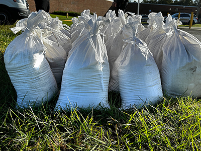
Multiple sandbag distribution sites operated by Volusia County and municipalities are currently available to help residents prepare their properties. Residents can find locations, operating hours, and other distribution information at www.volusia.gov/sandbags or through the Volusia Emergency Management app.
Residents, particularly those living in low-lying areas and near waterways, are encouraged to monitor weather forecasts and take appropriate precautions. Drivers should turn around if they encounter roads with standing water rather than attempting to cross, as water depth and underlying roadway conditions may be difficult to determine.
Additional Rises Possible Along the St. Johns River
Water levels along the St. Johns River remain elevated after significant rainfall across Central Florida about two weeks ago. The extent of additional rises from this week's weather system will depend largely on where the heaviest rainfall occurs within the river's watershed.
Because the St. Johns River flows northward, substantial rainfall farther south could eventually contribute to higher water levels in Volusia County. Forecasters anticipate that the river could continue rising gradually, with some locations potentially reaching their highest levels in late November or early December. Winds associated with the approaching weather system could also slow the river's northward flow, potentially keeping water levels higher for longer.
Volusia County will continue coordinating with the NWS and local and regional partners to monitor conditions and provide updates as additional information becomes available. Residents are encouraged to download the Volusia Emergency Management app through the Apple App Store or Google Play to receive severe weather notifications and other important emergency information.