How we know about them
What we do understand about native people in east Florida comes from many sources. There's the archaeological record of visible evidence from before and after contact with Europeans. The new arrivals produced accounts by explorers, priests, and government officials. Detailed colonial reports and even pictures are among the sources. For all their prejudices, information gaps, and tall tales, our predecessors left many helpful observations.
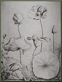
In particular, the paintings of Jacques Le Moyne provide a special view of east Florida's native people. This artist and mapmaker accompanied a French expedition to build a colony at the mouth of the St. Johns (the one soon destroyed by Menendez's Spanish), and during his stay in the mid-1560s, he observed native dwellings, attire, activities, and more.
Both Le Moyne and the leader of the French expedition, Rene de Laudonniere, also traveled up the St. Johns River as far as Lake George, recording the people they saw.
|
Exactly what details Le Moyne painted is uncertain. We see them through the engravings of Theodore de Bry, a German whose works were inspired, more or less, from Le Moyne's watercolors. De Bry's lively images were popular in Europe, but they don't always accurately portray east Florida. |
 De Bry print from the New York Public Library De Bry print from the New York Public LibraryRare Books Division. |
Another early observer of native people was Menendez's contemporary, Bartolome Barrientos. He chronicled the just-mentioned Spanish trip up the St. Johns to where the river narrowed, near modern-day Volusia. Some towns and tribes he noted are found in d'Escalante Fontaneda's 1569 memoirs of his adventures as a youth shipwrecked off the Florida coast.
In the 1600s, the tradition of reporting on the region's natives was continued by Spanish diplomat Alvaro Mexia, who observed large villages and mounds as he traveled through the Halifax River country.
In 1765, John Bartram, an American colonist dubbed "Royal Botanist" by George III, traveled with his son William through Georgia and Florida on his search for the source of the St. Johns River. William returned to the Southeast in 1773 and revisited the St. Johns, sketching plants, wildlife and mounds, while recording experiences among the Indians of his day, the Seminoles.
Once Florida became a U.S. territory in 1821, scouts and surveyors went to work mapping the area, noting the locations of trails, river crossings and Indian mounds. Other detailed observations appeared throughout the 1830s and 1840s in the letters and diaries of Seminole Indian War participants.
In 1848 Count Louis Pourtales of the U.S. Coastal Survey sketched the Enterprise midden as part of his investigations of shell mounds along the St. Johns River.
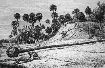
Enterprise Shell Mound sketched by Wyman in 1874
Our modern understanding of east Florida's archaeological past dates from the mid-1800s, when students dug into mounds and ended a debate about whether these features were natural. Pioneers in their field like the University of Pennsylvania's Daniel Brinton and Harvard's Jeffries Wyman checked along the coast and the St. Johns River. Wyman explored river mounds in the 1860s and 1870s, and his keen eye for locating promising sites still impresses archaeologists today.